Documentation

The COMUNIDAD Platform serves as the primary interface for end users to visualise data, analytical results, and multimedia content. The Platform provides a solution for creating user applications based on map windows, dynamic web pages, or standalone applications, using data and services provided by the Infrastructure. It cooperates with external applications through plugins to publish spatial data or maps.
The COMUNIDAD Infrastructure is the main component of the Architecture that manages and integrates datasets from different sources and scopes. It serves as the storage and processing component that communicates with other applications through various interfaces.
Platform overview
Infographics, presentations and videos providing a general overview of the Platform.


Getting started overview
Platform - Technical presentation
Platform - Added Value proposition
Pilot - Patagonia Solutions 1
Pilot - Patagonia Solutions 2
Pilot - The Future of Coffee
Platform components
This section describes components provided by the Platform.
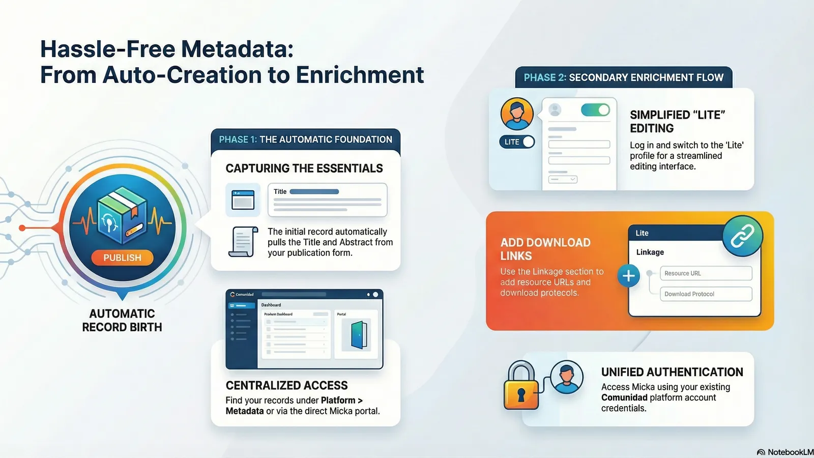
Micka metadata catalogue
The Micka metadata catalogue includes infrastructure services for spatial data, and available national services from Chile and Colombia will be gradually harvested and integrated into the catalogue. The last stable version (v7.008) of the Open Micka was installed on the Infrastructure server.
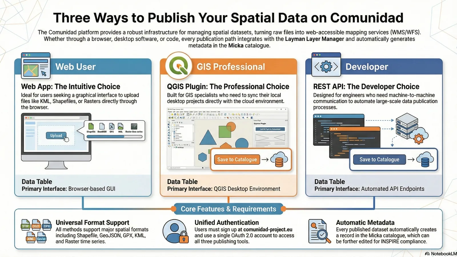
QGIS Layman plugin
The QGIS Layman plugin is a client for the Layman server, which provides WFS and WMS services. It is possible to create map compositions, store metadata and single layers, and load them back via WMS, WMTS or WFS. To deploy map composition on the Platform, you must first register.
Infrastructure datasets
Different types of spatial data are provided by the Infrastructure.
- Thematic spatial datasets
- Copernicus Sentinel-1 datasets
- Copernicus Sentinel-2 datasets
- Derivate products of satellite data
Infrastructure compoments
This section summarises components of the Infrastructure
Remote Sensing Data Processing System (RSDPS)
RSDPS is deployed on the Infrastructure server, and Copernicus Sentinel-1 and Sentinel-2 scenes are downloaded for defined localities in Chile and Colombia. The SpatioTemporal Asset Catalogue (STAC) is an open specification designed to improve the discovery, accessibility, and interoperability of geospatial data.
Use API key: eo-api-key-dev
Layman
Layman facilitates the online publication of geospatial data through a REST API. It offers two publication paradigms: layers and maps. Layers represent individual vector or raster datasets, including time series for raster data. Maps are collections of these layers. The last stable version (v1.23.2) of Layman was deployed on the Infrastructure server.
GeoServer
The last version (v2.21) of the GeoServer application was deployed on the Infrastructure and will provide different datasets integrated into the Infrastructure.
Tutorials
This page provides links to tutorial videos and PDF descriptions of the Platform or Infrastructure components.
Tutorials page